

Files
Download Full Text (2.1 MB)
Description
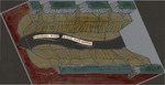
Folder of 4 drawings of Lake Winona historic and geologic structure, copied onto transparent paper, cut (irregular sizes), colored, and labeled with descriptive text. Drawings show Lake Winona, the Mississippi River path, the glacial river warren, river side channels, paths of local creeks (Burns Creek, Gilmore Creek, and Garvin Brook), geologic strata (dolomite, gravel, sand, silt, sandstones, shales), and the location of the city of Winona in relation to the river and lakes.
Publication Date
1960
Item Type
Book
Publisher
Library
City
Winona, Minnesota
Keywords
Geology; Minnesota; Glacial epoch Minnesota; Geology Minnesota; Winona County; Drawings Gilmore Creek Garvin Brook (Winona County, Minn.)
Department
Special Collections-Library
Recommended Citation
Fremling, Cal R., "Geology of Lake Winona 3-D color drawings" (1960). Cal Fremling Papers. 3.
https://openriver.winona.edu/calfremlingpapers/3
Rights Management
Requests to reproduce this image must be granted by the Winona County Historical Society.
Contributing Institution
Winona County History Center
Physical Format
Drawing
Master File Format
TIFF
Fiscal Sponsor
This project has been financed in part with funds provided by the State of Minnesota from the Arts and Cultural Heritage Fund through the Minnesota Historical Society.
Scanning Responsibility
Northern Micrographics
Date Digital
2019-06-24 00:00
Metadata Creation Responsibility
Anna Gaffey
Unique Identifier
2011.003.0068
