


Mississippi River; Dam Construction
Files
Description
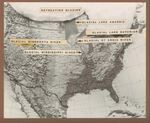
Set of 2 black and white photographs, 4 black and white negatives/transparencies, and 2 charts in an envelope labeled "b/w river charts, glacier coverage of North America." Some prints and negatives are duplicated elsewhere in collection. Images show maps of the Mississippi River (historical), Sam Gordy's Slough, two charts showing glacial coverage of the upper United States, and an aerial negative. Dates unknown. Print sizes: 8 x 11 inches. Negative sizes: 9 x 12 cm, 5 x 7 inches. Chart size: 6 x 8 inches. Part of the Cal R. Fremling collection.
Publication Date
1960
Item Type
Photograph
Publisher
Library
City
Winona, Minnesota
Keywords
Mississippi River; Maps; Charts
Department
Special Collections-Library
Disciplines
Animal Sciences | Aquaculture and Fisheries | Ecology and Evolutionary Biology | Entomology | Life Sciences | Terrestrial and Aquatic Ecology
Recommended Citation
Fremling, Cal R., "Mississippi River; Dam Construction" (1960). Cal Fremling Photographs. 30.
https://openriver.winona.edu/calfremlingphotographs/30
Rights Management
Requests to reproduce this image must be granted by the Winona County Historical Society.
Contributing Institution
Winona County History Center-Armory Museum
Dimensions
5 x 7 in
Master File Format
TIFF
Fiscal Sponsor
This project has been financed in part with funds provided by the State of Minnesota from the Arts and Cultural Heritage Fund through the Minnesota Historical Society.
Scanning Responsibility
Northern Micrographics
Date Digital
1559458800
Metadata Creation Responsibility
Anna Gaffey
Unique Identifier
2011.003.0087

Notes
No date available. A placeholder date of 1960-01-01 has been placed in the date field.