


Mississippi River charts, photographs, and negatives
Files
Description
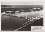
Set of 30 black and white photographs, negatives, and transparencies in 1 envelope labeled "B/w river views, negatives, river charts from 1939-1966." Images show aerial and elevated views of the Mississippi River, dikes, locks, and dams, and surrounding areas; historical river survey maps; Weaver and Weaver Bottoms area. Some prints are copies of images created by Army Corps of Engineers (U.S. Engineer Office, St. Paul, Minn.). Some prints and negatives are duplicated elsewhere in collection. Part of the Cal R. Fremling collection. Negative sizes vary including: 35mm (3 x 4 cm), 6.5 x 9 cm, 9 x 12 cm, 10 x 12.5 cm, 5 x 7 inches, and 8 x 10 inches. Print sizes vary including: 4 x 6 inches, 5 x 7 inches, 6 x 8 inches, and 8 x 10 inches.
Publication Date
1896
Item Type
Photograph
Publisher
Library
City
Winona, Minnesota
Keywords
Mississippi River; Aerial Photograph; Aerial Photographs; Lock and Dam # 5; Lock 5A; Lock and Dam; Charts
Department
Special Collections-Library
Disciplines
Animal Sciences | Aquaculture and Fisheries | Ecology and Evolutionary Biology | Entomology | Life Sciences | Terrestrial and Aquatic Ecology
Recommended Citation
Fremling, Cal R., "Mississippi River charts, photographs, and negatives" (1896). Cal Fremling Photographs. 28.
https://openriver.winona.edu/calfremlingphotographs/28
Rights Management
Requests to reproduce this image must be granted by the Winona County Historical Society.
Contributing Institution
Winona County History Center-Armory Museum
Dimensions
8 x 10 in
Master File Format
TIFF
Fiscal Sponsor
This project has been financed in part with funds provided by the State of Minnesota from the Arts and Cultural Heritage Fund through the Minnesota Historical Society.
Scanning Responsibility
Northern Micrographics
Date Digital
1559458800
Metadata Creation Responsibility
Anna Gaffey
Unique Identifier
2011.003.0084
